
6:00 p.m.: Tornado Watch canceled for Tampa Bay. Some wind and rain remains.
4:04 p.m.: A Tornado Watch remains in effect until 6 p.m. for six counties in Central Florida, including Hardee, Polk, Desoto, Highlands, Manatee, and Sarasota.
3:46 p.m.: Parts of Hillsborough, Pasco, and Polk counties are under a severe thunderstorm warning until 4:15 p.m.
Wind gusts to 60 mph and penny-sized hail is possible.
%INLINE%
3:30 p.m.: A tornado warning issued for Hillsborough County, including South Tampa, was canceled as quickly as it was issued.
An area of rotation seen on radar prompted forecasters to issue the warning, but the storm weakened not long thereafter.
3:19 p.m.: The tornado warning earlier in effect for several Tampa Bay counties has been canceled. The immediate threat of a tornado has passed.
However, a strong line of thunderstorms continues to push into the area, and a tornado watch remains in effect until 6 p.m.
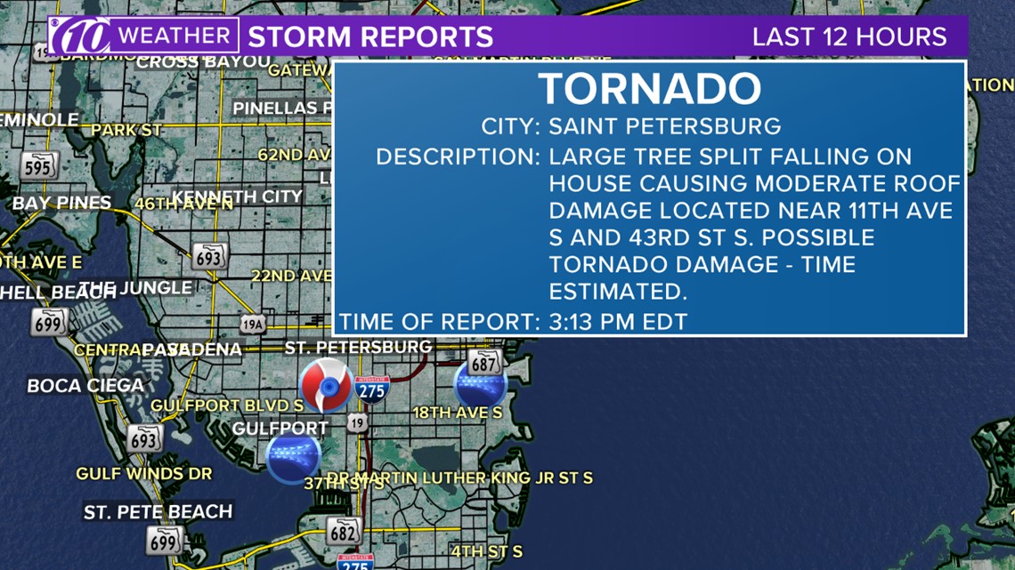
3:13 p.m.: Possible tornado damage reported out St. Petersburg in Pinellas County. According to the National Weather Service, "a large tree split, falling on house, causing moderate roof damage." The house is reportedly located near 11th Ave. S. and 43 St. S.
Download the 10News app: Get breaking news and weather alerts when they happen
3:12 p.m.: A waterspout was reported by the public near the Sunshine Skyway Bridge. It is not believed to have moved onshore caused any damage.
2:55 p.m.: A tornado warning is in effect for Hillsborough, Manatee and Pinellas counties until 3:30 p.m.
This is a radar-indicated tornado, meaning National Weather Service meteorologists have issued the warning based on the rotation they're seeing on radar. It has not yet been seen in person.
This is the time to get to a safe place -- the lowest, most interior room of your home.
%INLINE%
2:09 p.m.: The Coast Guard responded to the Bradenton pier on a report of a boater caught underneath.
They were able to safely tow him and his 10-foot dingy to shore.
1:45 p.m.: A line of strong storms is just off the Florida Gulf coast. It's forecast they'll be entering the Tampa area between 2:30-3 p.m.
A weather station on Clearwater Beach recorded a wind gust of 39 mph just ahead of the storms.
%INLINE%
Weather update: Strong storms push toward Tampa Bay
1 p.m.: Now this is an angry Gulf of Mexico!
The EarthCam view from Treasure Island, Florida, shows strong winds pushing up big waves. Weather service forecasters earlier warned of a 2-3 foot water level rise above high tide just because of the strong winds pushing against the shore.
Despite calls to stay out of the water, you might see a surfer or two.
%INLINE%
12:32 p.m.: A tornado watch now includes all of Tampa Bay. It goes until 6 p.m. and includes Citrus, Hernando, Highlands, Hillsborough, Manatee, Pasco, Pinellas, Polk and Sarasota counties.
A few tornadoes and wind gusts to 70 mph are possible within the red area.
%INLINE%
12:11 p.m.: A 2-3 foot water level rise above normal high tide is possible along the Citrus, Hernando, Pasco and Pinellas coasts as a strong squall line moves through.
Stay AWAY from the water as the storms push closer to shore -- strong rip currents are possible.
11 a.m.: The air show at the annual Sun 'n Fun Fly-In in Lakeland is canceled.
The event site gates will close at 1 p.m. today, and guests are asked to stay clear of the exhibit area to avoid running into vendors and exhibitors leaving the event.
10:43 a.m.: The Shark's Tooth Festival in Venice is canceled, according to the city's police department.
10:20 a.m.: The Sugar Sand Festival on Clearwater Beach is closed for today because of the strong storm risk.
10:08 a.m.: A tornado watch is in effect until 6 p.m. for Citrus and Hernando counties northward. While a few tornadoes can be expected in the watch, so too is the threat for damaging winds in excess of 70 mph.
Original story below:
ST. PETERSBURG, Fla. -- If you like the heat and the humidity, there's not much to complain about for the first half of the day.
Then the washout comes.
The system that brought strong to severe thunderstorms -- some even producing tornadoes -- across the south in recent days finally reaches Florida today. Although widespread severe thunderstorms aren't anticipated, some of those could potentially be on the stronger side.
Full forecast: Storms today, some could be severe
Damaging winds in excess of 60 mph is the main threat, but a tornado or two cannot be ruled out.
Computer models show a squall line of stronger storms pushing into Florida's Gulf coast between 2-4 p.m. The line sticks around through the early evening before finally exiting the Tampa Bay region by 8 p.m.
%INLINE%
Storm Prediction Center meteorologists place the greatest risk of severe weather just north of Tampa. However, a marginal risk still exists for the region, meaning the farther north you go, the greater the chance of severe weather.
It'll be after this time there will start to be a noticeable change in the air. These storms will be associated with a strong cold front, and it'll be after its passage that winds shift out from the west-northwest and bring in much cooler and drier air.
►Make it easy to keep up-to-date with more stories like this. Download the 10 News app now.
Have a news tip? Email tips@wtsp.com, visit our Facebook page or Twitter feed.