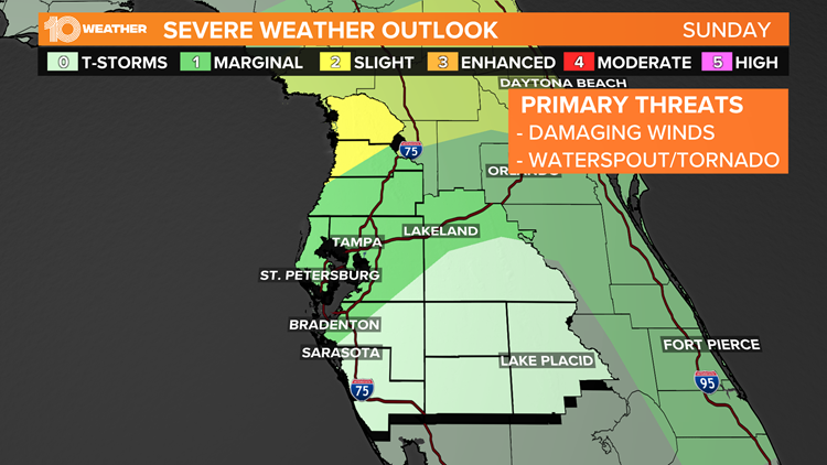
ST. PETERSBURG, Fla. — A few strong-to-severe thunderstorms with damaging gusts and a brief tornado will be possible Sunday across northern and central Florida, including most of the Tampa Bay area.
The Storm Prediction Center has put Tampa Bay in a marginal (level 1) risk Sunday. A higher-level slight risk (level 2) exists for portions of Citrus and Hernando counties, where the atmosphere is more conducive to severe thunderstorm development.
A waterspout came ashore as an EF-0 tornado early Sunday morning, damaging some condos and roofs in the Boca Ciega Bay area, according to the National Weather Service.
A series of disturbances will move from the northern Gulf through the southeastern United States. A stationary front will be situated across the northern Gulf and along the Georgia-Florida border.
The region south of the front is expected to become moderately unstable with rather humid air, increasing the chance for scattered strong-to-severe thunderstorms.
Locally, strong wind gusts are the main threat. A tornado can’t be ruled out.
Additional strong storms may develop farther south, along with a developing sea breeze.
This severe storm risk should diminish Sunday evening, as instability gradually weakens with the loss of daytime heating.


- Trump acquitted: Senate votes 57-43 at 2nd impeachment trial
- Strong, severe storms possible on Valentine's Day
- Lakeland hospital employee accused of sexual battery of 82-year-old patient, police say
- Polk County teacher accused of attacking 2 students after basketball game
- Florida Walmarts 'accidentally' opened up COVID-19 vaccine appointments for people under 65
►Breaking news and weather alerts: Get the free 10 Tampa Bay app
►Stay In the Know! Sign up now for the Brightside Blend Newsletter