
ST. PETERSBURG, Fla. — Tropical Storm Barry Highlights (11 p.m. ET Thursday)
- Tropical Storm Barry gained some strength. Dangerous storm surge, heavy rains and strong winds are expected across the north-central Gulf coast.
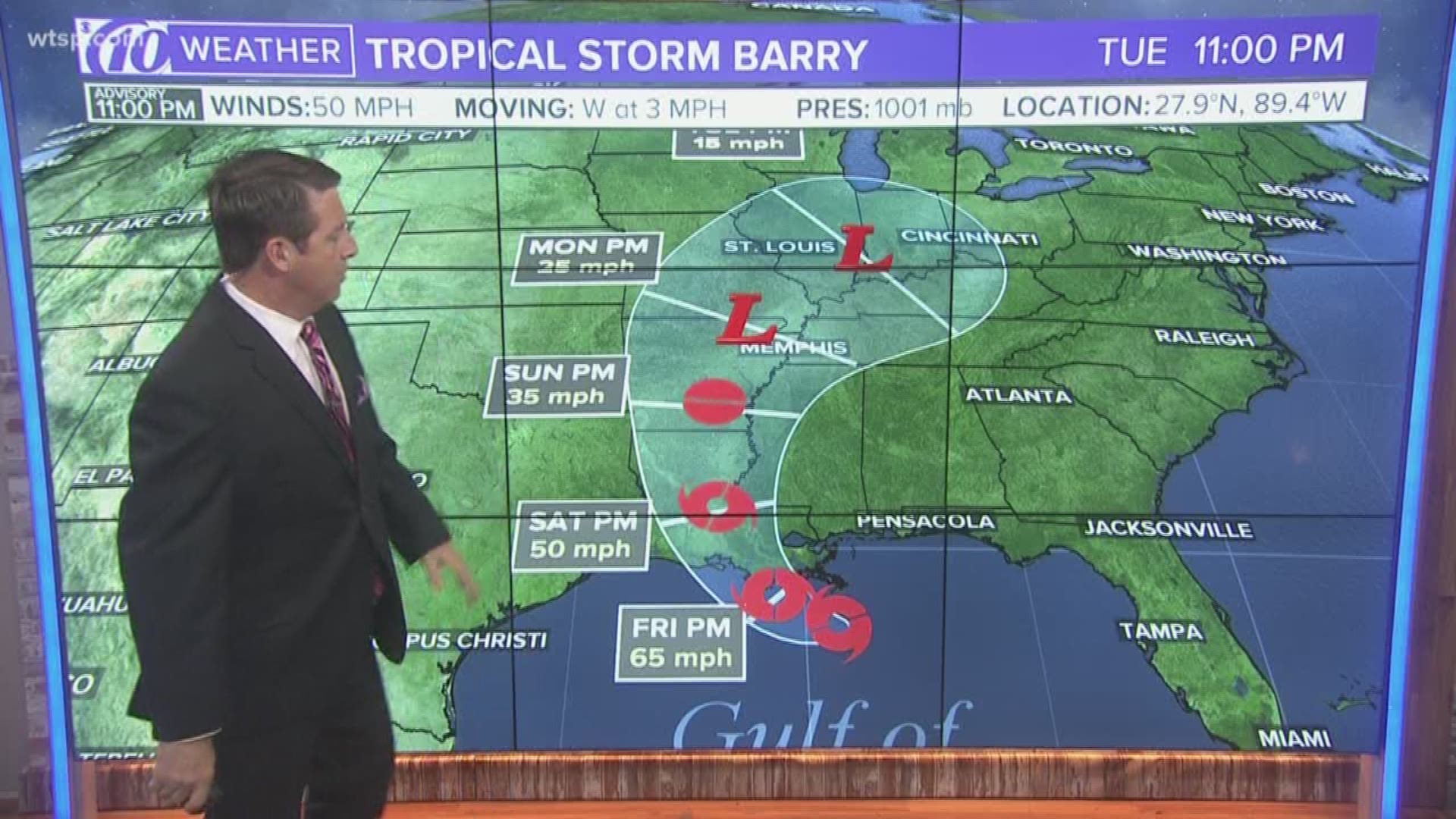
- At 11 p.m. Thursday, it was located about 85 miles south-southwest of the mouth of the Mississippi River.
- Maximum sustained winds are being clocked at 50 mph. The storm is moving west at 3 mph.
- Additional strengthening is expected, but Barry is likely to stay just below hurricane strength. However, anything is possible -- and a hurricane warning is still in effect.
- A tornado or two is possible Friday across parts of Louisiana and Mississippi.
- For Tampa Bay: Expect minimal impacts, with breezy conditions, slightly higher tides along the coast and periods of heavy rain. We'll be in the clear late Friday.
Tropical Storm Barry Advisories (11 p.m. ET Thursday):
- A hurricane warning has been issued for the coast of Louisiana from Intracoastal City to Grand Isle.
- A tropical storm warning is in effect from the mouth of the Pearl River to Grand Isle, from Intracoastal City to Cameron and for Lake Pontchartrain and Lake Maurepas -- including metropolitan New Orleans.
- A storm surge warning is in effect from the mouth of the Atchafalaya River to Shell Beach.
- A storm surge watch has been issued for Shell Beach to the Mississippi/Alabama border, from the mouth of the Atchafalaya River to Intracoastal City and for Lake Pontchartrain.
- A hurricane watch is in effect from the mouth of the Mississippi River to Grand Isle and from Intracoastal City to Cameron, Louisiana.
- A tropical storm watch has been issued from just east of the mouth of the Pearl River to the Mississippi/Alabama border.
Interactive Tropical Tracker
Latest Forecast Cone
Full Tropical Storm Barry Forecast:
Tropical Storm Barry has formed in the northern Gulf of Mexico. As of 11 p.m. ET Thursday, it was located about 85 miles south-southwest of the mouth of the Mississippi River or about 165 miles southeast of Morgan City, Louisiana.
Barry is moving west at 3 mph. And, it's expected to continue moving that direction during the day on Thursday.
The tropical weather system is forecast to turn slowly toward the west-northwest through Friday, take a turn toward the northwest Friday night and head north on Saturday. The center of Tropical Storm Barry is expected to be near or over the central or southeastern coast of Louisiana by Friday night or Saturday. From there, meteorologists expect it to move inland into the Lower Mississippi Valley on Sunday.
Aircraft reports from the Air Force Reserve and NOAA Hurricane Hunters suggest maximum sustained winds are around 50 mph, with higher gusts. More strengthening is expected. And, Barry could become a hurricane late Friday or early Saturday when the center gets near the Louisiana coast. But, our latest forecasts suggest it will be just shy of hurricane strength.
Earlier in the day on Thursday, an oil rig east of the Mississippi River's mouth reported sustained winds at 40 mph and a wind gust of 52 mph.
Meteorologists say tropical storm-force winds are extending up to 140 miles outward from the storm, mainly south of Barry's center.
The storm is expected to weaken as it moves inland.
Tropical Storm Barry warnings and watches:
A hurricane warning is now in effect for the Louisiana coastline. And, that's not nearly the only advisory issued so far. People living from the upper Texas Gulf Coast to the Florida Panhandle should monitor weather forecasts because more advisories could be coming soon.
Hurricane Advisories
- A hurricane warning has been issued for the coast of Louisiana from Intracoastal City to Grand Isle.
- A hurricane watch is in effect for the mouth of the Mississippi River to Grand Isle and Intracoastal City to Cameron.
Tropical Storm Advisories
- A tropical storm warning is in effect from the mouth of the Pearl River to Grand Isle, from Intracoastal City to Cameron and for Lake Pontchartrain and Lake Maurepas -- including metropolitan New Orleans.
- A tropical storm watch has been issued from just east of the mouth of the Pearl River to the Mississippi/Alabama border.
Storm Surge Advisories
- A storm surge warning is in effect from the mouth of the Atchafalaya River to Shell Beach.
- A storm surge watch has been issued for Shell Beach to the Mississippi/Alabama border, from the mouth of the Atchafalaya River to Intracoastal City and for Lake Pontchartrain.
What do Tropical Storm Barry warnings and watches mean:
A hurricane watch means hurricane conditions are possible in the next 48 hours. A hurricane warning means hurricane conditions are expected within the next 36 hours.
A storm surge warning means rising water may move inland from the coastline and pose life-threatening conditions in the next 36 hours. People living in those areas should take immediate action to protect their lives and property from rising water. If local officials tell you to evacuate, get out.
A storm surge watch means rising water may move inland and pose life-threatening conditions in the next 48 hours.
A tropical storm watch means tropical storm conditions are possible within the next 48 hours.
Tropical Storm Barry Potential Impacts:
Rainfall has already exceeded 6-9 inches in parts of New Orleans, causing flooding. Forecasters are warning of potential 3-5 foot storm surge across parts of the Gulf coast.
According to the National Hurricane Center, Tropical Storm Barry is expected to produce total rainfall accumulations of 10 to 20 inches near and inland of the central Gulf Coast through early next week, with isolated maximum rainfall amounts of 25 inches across portions of eastern Louisiana and southern Mississippi.
A tornado or two is possible Friday and Friday night across the southern parts of Louisiana, Alabama and Mississippi.
The combination of dangerous storm surge and tides will likely cause normally drier areas along the coast to be flooded. If peak storm surge happens at the time of high tide, you could see water at the following heights:
- Mouth of the Atchafalaya River to Shell Beach: 3 to 6 feet
- Shell Beach to the Mississippi/Alabama border: 2 to 4 feet
- Intracoastal City to the mouth of the Atchafalaya River: 3 to 5 feet
- Lake Pontchartrain: 2 to 4 feet
As the system develops, it will track west away from the Florida Peninsula. However, some indirect impacts will still be possible.
As Barry strengthens, the winds will begin to increase, especially along the coast. Wind speeds are likely to range between 10-15 mph with occasional gusts as high as 30-35 mph.
This persistent wind out of the south and southwest, potentially into Friday, might result in higher than normal tides; and some minor coastal flooding could be possible.
In addition to breezy conditions and the threat for minor coastal flooding, the developing system will draw up abundant tropical moisture. Any showers and storms that develop will have the potential to produce locally heavy rain and possibly result in flooding. Generally speaking, flooding as a result of heavy rain is not a major concern for Tampa Bay, but some localized flooding may be seen.
Forecast models are in fairly good agreement of the track of the storm through Thursday morning, but after that, there is a fair amount of divergence in thinking. The spread of the greatest impact stretches from Alabama to Texas with Louisiana and Mississippi right in the middle.
The European Model, historically one of the more reliable forecast models, strengthens the storm as it approaches the Louisiana Coast Friday into Saturday.
Regardless of development, this system has the potential to produce heavy rainfall along portions of the northern and eastern U.S. Gulf Coast later this week and into the weekend. Some forecasts suggest that rainfall totals could be greater than 1 foot along the central Gulf coast.
While the focus with a tropical system is often with the wind speeds, flooding rains are often the deadliest hazard. The threat for inland flooding needs to be monitored closely all along the central and eastern Gulf coast.
In any event, we're well into the swing of hurricane season. It's not too late to prepare a hurricane kit and have a plan in place should a storm threaten the area.
10News is your Hurricane Headquarters:
- Welcome to Florida! Here’s how to prepare for a hurricane
- What's the difference between a hurricane watch and warning?
- Hurricane season 2019: How to check your supplies, evacuation zones, insurance coverage
- New emergency rules allow for shoulder use during hurricane evacuations
- Tampa Bay most vulnerable to damage, flooding with major hurricane
►Track the weather and get severe alerts when they happen: Download
the 10 News app now.