ST. PETERSBURG, Fla. — Tuesday morning, hurricane researches at Colorado State University (CSU) increased their seasonal hurricane forecast, calling for a number of storms that is nearly double what is average.
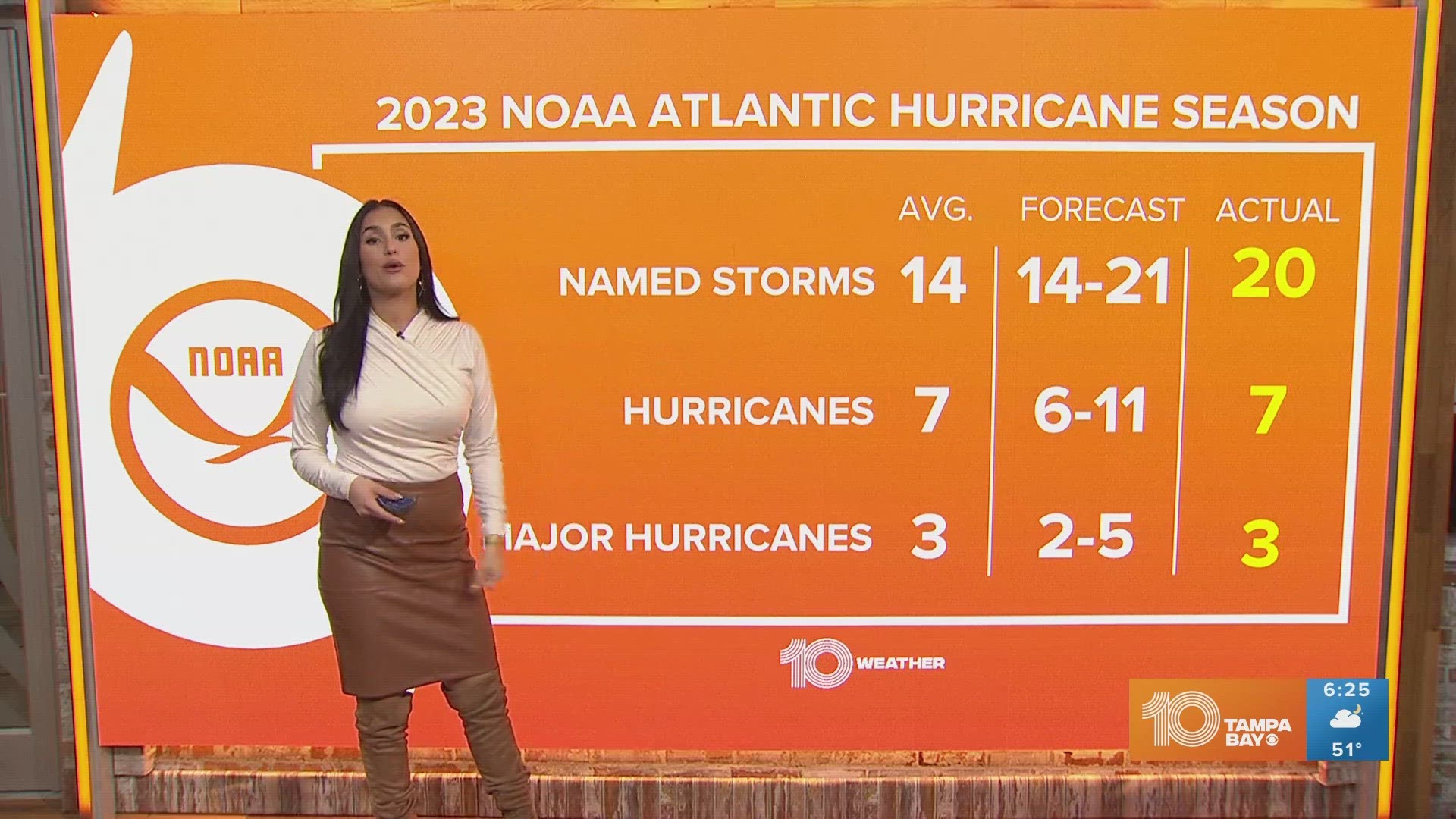
The new forecast is for 24 named storms and 12 hurricanes. This includes the 11 storms and two hurricanes we’ve already seen. An average season typically brings 12.1 named storms, 6.4 hurricanes and 2.7 major hurricanes, making 2020 a season that could feature nearly two hurricane seasons in one year.
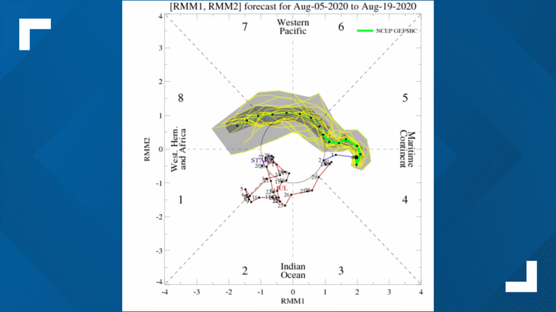
However, it’s not likely to be all that busy over the next 10-plus days due to the Madden-Julian Oscillation (MJO) and a Kelvin Wave.
What’s it all mean? Several times a year, the MJO is a strong contributor to various extreme events in the United States, including Arctic outbreaks during winter. MJO can also play a significant part in tropical development.
The MJO is an eastward-moving area of increased uplift (resulting in more rainfall and winds) that circles the globe in the tropics. In general, it takes this disturbance 30-60 days to circle the globe and return to its starting point.
There are two phases associated with the MJO. A convective (enhanced rainfall) phase, and a suppressed rainfall phase.
These phases normally cover roughly half the globe, so the result is roughly half the planet sees enhanced rain and storms and half the planet sees suppressed rain and storms.

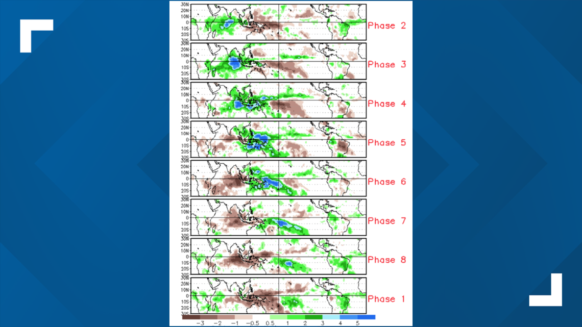
The phase of the MJO plays a significant part in tropical development. Over the past several weeks or so, the MJO has been in phases 1 and 2. Those are phases that tend to favor a general upward vertical motion in the Atlantic Basin, which is more favorable for convection and the survival of tropical waves.

For the first few weeks of August, the MJO has the tropics looking quiet (not counting a minor "fish" storm development) with a suppressed rainfall phase (7, 6, 5 and 4). There really needs to be in phases 1, 2, 3 or 8 for activity in the Atlantic Basin.
Look for a return of more favorable conditions for the last week of August, setting up the peak period of tropical activity that usually occurs in September.

The science surrounding the MJO continues to evolve, and as we continue to learn more about the MJO and its influences, better long-term hurricane forecasts should result.
- Court hearing for Tampa teen accused of being 'mastermind' behind Twitter hack gets interrupted by porn
- Florida's largest teachers' union gets emergency hearing in lawsuit to stop schools from reopening
- Hillsborough County votes to dissolve its emergency policy group
- Another 247 people in Florida have died from COVID-19
- Lebanese confront devastation after massive Beirut explosion
- Early voting begins across Tampa Bay this week
FREE 10 TAMPA BAY APP:


►Stay In the Know! Sign up now for the Brightside Blend Newsletter