The latest updates from the National Hurricane Center in Miami:
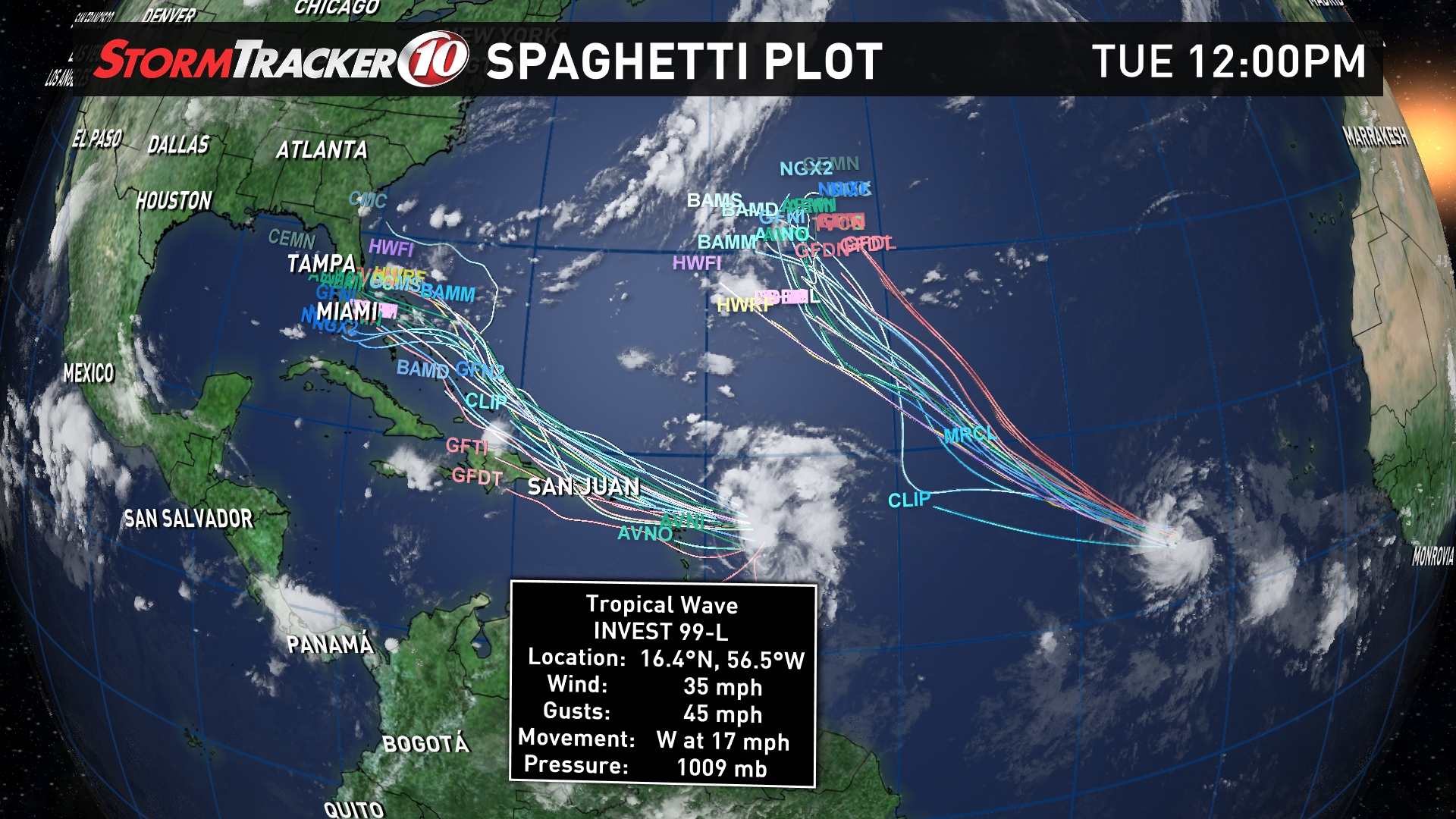
Meteorologists are keeping a close eye on tropical wave 99L, which has been given a 50 percent chance of strengthening over the next 48 hours as it nears the Leeward Islands.
As of 8:00 a.m., Invest 99L is categorized as a "large area of disorganized showers and thunderstorms located a few hundred miles east of the Leeward Islands," according to the NHC.
Forecasters expect the system to develop under favorable environmental conditions as it heads west-northwest at 15 to 20 miles per hour toward the northern Leeward Island and the Greater Antilles.
{"author_name":"Bobby Deskins Weather","author_url":"https://www.facebook.com/bobby.deskins.weather/","provider_url":"https://www.facebook.com","provider_name":"Facebook","success":true,"height":281,"html":"&#lt;div id=\"fb-root\"&#gt;&#lt;/div&#gt;\n&#lt;script&#gt;(function(d, s, id) {\n var js, fjs = d.getElementsByTagName(s)[0];\n if (d.getElementById(id)) return;\n js = d.createElement(s); js.id = id;\n js.src = \"//connect.facebook.net/en_US/sdk.js#xfbml=1&version=v2.3\";\n fjs.parentNode.insertBefore(js, fjs);\n}(document, 'script', 'facebook-jssdk'));&#lt;/script&#gt;&#lt;div class=\"fb-video\" data-href=\"https://www.facebook.com/bobby.deskins.weather/videos/1089241294463234/\"&#gt;&#lt;blockquote cite=\"https://www.facebook.com/bobby.deskins.weather/videos/1089241294463234/\" class=\"fb-xfbml-parse-ignore\"&#gt;&#lt;a href=\"https://www.facebook.com/bobby.deskins.weather/videos/1089241294463234/\"&#gt;&#lt;/a&#gt;&#lt;p&#gt;&#lt;/p&#gt;Posted by &#lt;a href=\"https://www.facebook.com/bobby.deskins.weather/\"&#gt;Bobby Deskins Weather&#lt;/a&#gt; on Tuesday, August 23, 2016&#lt;/blockquote&#gt;&#lt;/div&#gt;","type":"video","version":"1.0","url":"https://www.facebook.com/bobby.deskins.weather/videos/1089241294463234/","width":500}
Particular attention is paid to the system as it heads over the warm waters near the Dominican Republic and The Bahamas. Current models have placed Florida in the potential cross hairs of the storm.
The Hurricane Hunter aircraft will investigate the system on Tuesday.
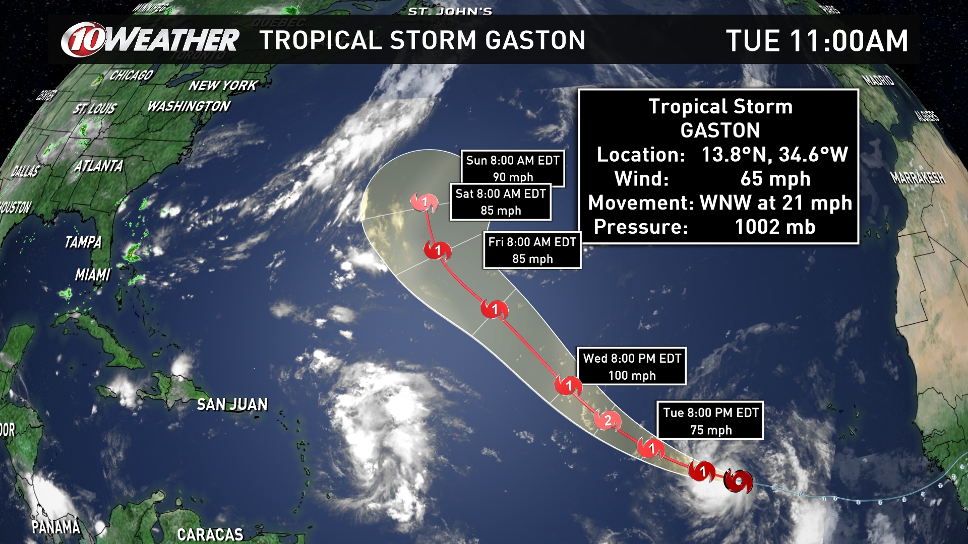
Meanwhile, Tropical Storm Gaston is strengthening as it heads west-northwest at 21 mph with maximum sustained winds of 65 mph. Gaston should strengthen to hurricane force later on Tuesday.
As of 5 p.m., the system is located 765 miles west of the Cabo Verde Islands and is expected to make a gradual turn northwest accompanied by a decrease in forward speed.
Gaston does not present a threat to any coastal areas and is expected to remain in the Atlantic Ocean.
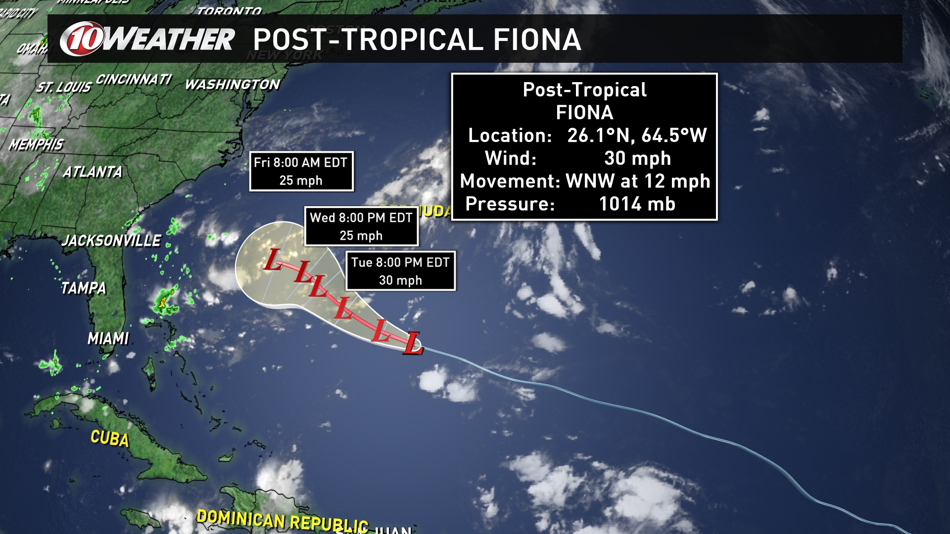
Fiona has mostly dissipated and has been downgraded to a Post-Tropical Cyclone. The system is located 430 miles south of Bermuda and has maximum sustained winds of 30 mph. Fiona is moving west-northwest at 12 mph.
The storm will weaken over the next "couple of days," according to the NHC.
Get the latest info and track the storms with the 10News App.
iPhones --> http://apple.co/26SKuII
Android --> http://bit.ly/1SYfvnh