While mid-September was the statistical peak of hurricane season, our focus tends to shift to the Gulf of Mexico and the Caribbean Sea during the month of October.
That is because water temperatures in the Atlantic Ocean typically start to cool and wind shear increases, so the majority of the tropical activity shifts into the Caribbean Sea and Gulf of Mexico, where water temperatures are usually still very warm.
This is also why we tend to see a slight "second peak" to hurricane season during the month of October.


Here are some of the more historic storms that initiated in that region this time of year and the impact they left behind.
Hurricane Wilma (2005) - From what was already a record-breaking year for tropical activity, Wilma too went down in the record books. This storm initially formed into a tropical depression in the Caribbean Sea on Oct. 15, became a hurricane on the 18th, then rapidly intensified to a category 5 hurricane, reaching the Yucatán Peninsula. Once Wilma emerged in the Gulf of Mexico, it raced to the northeast, making landfall as a category 3 hurricane south of Marco Island, at Cape Romano, Florida. Wilma then crossed the Florida peninsula and emerged into the Atlantic Ocean. Hurricane Wilma caused nearly $22 billion in damages just in the United States. Mexico reported more than $7 billion in damages.
Hurricane Sandy (2012) - Also known as "Superstorm Sandy," was considered the deadliest and most destructive storm at the time, especially for the northeast, with nearly $70 billion in damages and approximately more than 200 direct and indirect deaths from the storm.
Sandy initialized as a tropical wave in the western Caribbean on Oct. 22. Becoming a hurricane on Oct. 24, Sandy then quickly moving through Jamaica, Cuba and the Bahamas. Sandy remained just off the east coast of the U.S. for days while moving north, affecting the coastal regions of the U.S. before then making a sharp left turn to the northeast U.S., making its final landfall in New Jersey and causing significant damage to the state, as well as New York City.
Hurricane Michael (2018) - Incredibly destructive storm surge and wind damage. This was actually the first category 5 storm to hit the United States since Hurricane Andrew in 1992. While initially a broad area of low pressure in the southwestern Caribbean, this disturbance slowly formed into a tropical depression on Oct. 7. Michael then quickly became a hurricane the next day near western Cuba, before drifting north into the eastern Gulf of Mexico. Michael rapidly intensified, making landfall with 160-mph winds in the panhandle of Florida, in Mexico Beach on Oct. 10. Seventy-eight deaths were related to this storm, as well as $25.1 billion in damages, making this the strongest storm to hit the Florida Panhandle.
Other impactful storms during the month of October include Hazel in 1954, Opal in 1995, and Matthew in 2016.

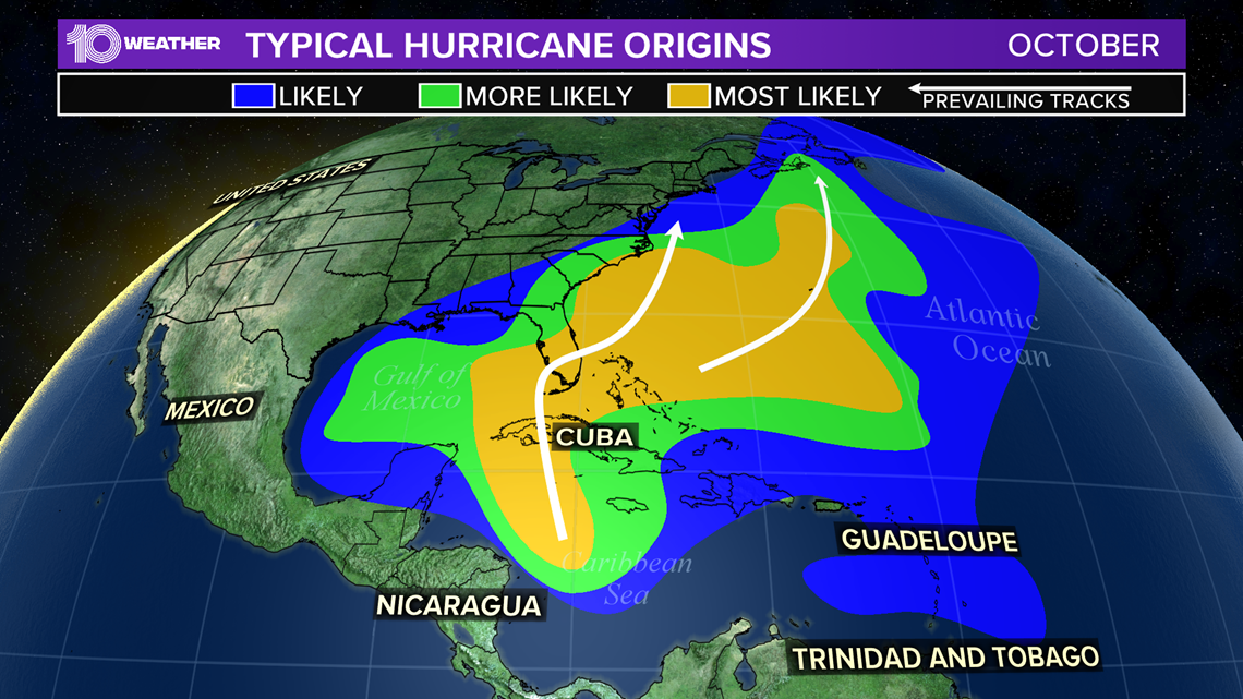
The map above shows the prevailing tracks that these storms take for the month of October. Most form in the Caribbean Sea or Gulf of Mexico and move north and then northeastward. Depending on the exact circumstances, this setup can often bring storms close to the Florida peninsula.
All the more reason we simply can’t let our guard down this month. While activity drops quickly in November, hurricane season continues until Nov. 30.
What other people are reading right now:
- Amy Coney Barrett back on Capitol Hill for senators' final questions
- Trump, Biden to hold competing town halls instead of debating Oct. 15
- Florida mom accused of killing her son, lying to police sentenced 50 years after pleading guilty
- First Trump, now Biden: As campaigns hit Florida hard, nearly 2 million people have already voted
- Maskless Gov. Ron DeSantis slaps high-fives with people at Trump's Florida rally
- What you need to know about the 6 constitutional amendments on Florida ballots
►Breaking news and weather alerts: Get the free 10 Tampa Bay app
►Stay In the Know! Sign up now for the Brightside Blend Newsletter