
TAMPA, Fla. — Florida isn't called the Sunshine State for nothing, and it looks like the summer sunshine in Tampa has left its mark.
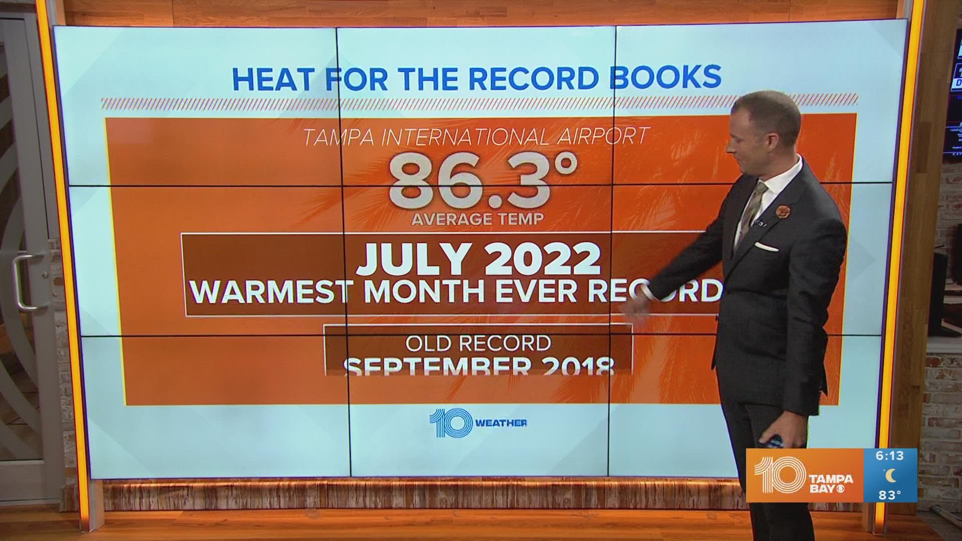
The temperature at the Tampa International Airport, where the official records for Tampa are kept, had been the hottest ever recorded for most of July. Now confirmed by the National Weather Service in Ruskin Monday morning, July 2022 had an average temperature of 86.3 degrees.
At first glance, that may not sound impressive but when you consider that this value includes the low temperatures and the high temperatures, you get a better idea of just how warm this month has been.
Warmest month ever recorded in Tampa
Warm is perhaps an understatement — July 2022 in Tampa is now officially the hottest month ever recorded in Tampa. Previously, the hottest month on record for Tampa was September 2018 when the average temperature for the entire month was 85.8 degrees.


Hottest consecutive months
Not only was July the hottest month on record, but the heat over June and July landed itself at the top of the list for the hottest consecutive months ever recorded.


The average temperature from June 1 through July 2022 was 85.7 degrees. The record warmest two months in a row are July-August 2020 when the average temperature was 85.1.
On track for hottest year ever recorded
Naturally, summer brings the biggest heat and humidity, but unusually warm temperatures have been the resounding theme so far in 2022 in Tampa Bay. At the current pace, 2022 is on track for the hottest year on record in Tampa.

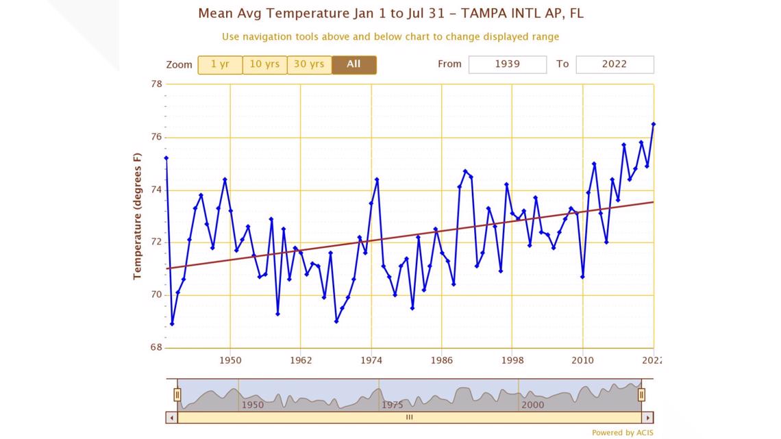
To date, 2022 is outpacing 2020 as the hottest year on record by 0.7 degrees. The average temperature so far this year in Tampa is 76.5 degrees whereas, in 2020, the average temperature through July was 75.8 degrees.
What's driving the heat
The big contributor to the warmer than normal temperatures has been the overnights. Factors that result in warmer nights are days when it doesn't rain as much. This results in temperatures not getting their "normal" knock-down.
Also, there have been several stretches where the general wind flow in Tampa Bay has been out of the southwest. A southwesterly flow will draw in warmer (and more humid) air off of the Gulf of Mexico keeping temperatures warmer through the night than they would be when winds have an easterly component.


Another factor that has influenced the unusual warmth is a persistent easterly flow. When a pattern sets up where there is a persistent easterly flow it prevents or at least delays the Gulf coast sea breeze from pushing inland.
The sea breeze works as a temperature-moderating force as it sweeps through Tampa Bay. If the sea breeze doesn't start to move inland until later in the day then temperatures will be able to warm that much more. The second factor in a delayed sea breeze is that it acts as a catalyst for showers and storms.
A later sea breeze will result in storms developing later in the day which will, again, result in warmer afternoon temperatures.
Is the record heat a product of climate change?
The short answer is kind of, yes and no.
YES — There's no doubt that climate change has contributed to some of the heat that Tampa Bay has experienced lately. The average annual temperature for Tampa has increased by 2.5°F since records began in 1891.

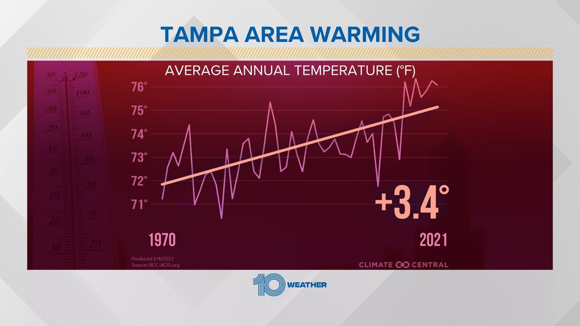
On average, urbanized areas in West Central and Southwest Florida have seen an increase of 2.5° to 3.0°F over the last century. These increases are consistent with a global rise in temperature over the last century.
NO — The general seasonal weather patterns, including the sea breeze and movement of the subtropical ridge of high pressure which drives summertime weather are completely natural and normal.
We are currently in a La Niña pattern (second year in a row). La Niña patterns tend to contribute to warmer and drier conditions for Tampa Bay and even most of the state of Florida.
Hot is hot — and that could be deadly
At the end of the day, it doesn't look like the heat is going to end anytime soon as we head through the second half of summer. Even if temperatures in Tampa Bay get a little closer to normal, the average high temperatures don't drop below 90 degrees until late September.
Heat is the leading weather-related killer in the United States accounting for an average of 143 fatalities in the U.S. over the last 30 years.


Take extra precautions if you work or spend time outside on days like today. When possible reschedule strenuous activities to the early morning or evening time when the impact of the heat on your body will be less intense.
Know the signs and symptoms of heat exhaustion and heat stroke. Wear lightweight and loose-fitting clothing when possible.


And to reduce risk during outdoor work, the Occupational Safety and Health Administration recommends scheduling frequent rest breaks in shaded or air-conditioned environments. Anyone overcome by heat should be moved to a cool and shaded location.
Heat stroke is an emergency! Call 911 immediately.