Here are 10 things you want to know about Tropical Depression Eta as it heads toward Tampa Bay.

- About to intensify into Tropical Storm Eta Models are in decent agreement over the next 24-48 hours with the track and continuing to show intensification as it tracks northeast through the Caribbean Sea toward Cuba. Models show a re-curve to the north then northwest beyond 48 hours when it approaches Cuba.
- Expected to make it into Gulf of Mexico This is where the track becomes tricky. The two features that will contribute to the steering flow will be a trough over the western Gulf of Mexico and the ridge over the east coast. The ridge turns the storm into the Gulf after its passage over Cuba. The trough will push it back toward the west coast of Florida.
- Rain chances will be on the increase this weekend Rain and storm chances will steadily increase starting Saturday as more moisture is moved northward. Temperatures and ew points will be on the warmer side with daytime highs in the low to mid 80s and overnight lows in the low 70s.
- Winds pick up for the weekend As Eta starts to approach the region this weekend, winds will increase. Saturday winds will gust to near 25 mph at times. Sunday, winds could gust to 30 mph. Early next week, 40+ mph Monday and Tuesday.
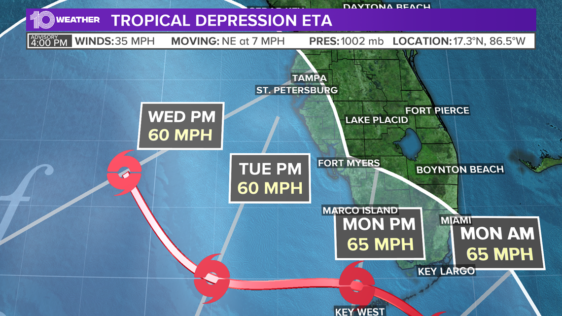
- Eta will move quickly this weekend Eta will move very quickly towards Cuba through the weekend. In fact, it should already be north of the island nation by Sunday morning. This is when the storm is expected to turn fairly sharply to the northwest toward the Gulf of Mexico.
- What happens in the Gulf is more uncertain There will be some uncertainty how far into South Florida Eta makes it before making that sharp northwest turn. Then, how far off the west coast of Florida will Eta be positioned. The intensity of the storm at this point is also still a bit uncertain.
- The Gulf of Mexico won’t be conducive for developing Eta into a hurricane If Eta does indeed make it into the Gulf of Mexico next week, its intensity would likely be limited as the atmosphere would probably be unable to support anything above a high-end tropical storm or a low-end hurricane. That’s because the storm will be encountering cooler sea surface temperatures and, more important, wind shear. Wind shear is a disruptive change in wind speed and/or direction with height into the atmosphere. No models are currently predicting a hurricane.
- What’s likely to happen in Tampa Bay? It’s still too early to give a reliable forecast for Tampa Bay in regards to Eta’s effect on our area. Much will depend on the track of the storm in terms of how close to our coast. The other factor will be the intensity of Eta. With the current projected path and intensity of Eta, Tampa Bay might experience tropical storm conditions sometime between Monday and Wednesday.
- Tampa Bay’s strongest winds It’s too early to predict how strong the winds will be. The strongest winds will be near the center of the storm, so the closer the storm is to our coast, the stronger our winds will be. With that said, those along coastal areas are likely to see the strongest winds. Max winds near the center, now appear to be near 60 mph, with higher gusts. The current forecast would likely keep those strongest winds just offshore. Even inland, winds will be very gusty early next week.
- How much rain? Like, wind, rain totals will depend on how close the storm comes to our coasts. There could be areas that experience flooding, but this is a part of the forecast that can’t really be given until we get a more confident projection of Eta’s track and intensity.
The 10 Tampa Bay team will track Eta around-the-clock as it develops through the weekend. It is 2020 after all though, and the hurricane season to date has been filled with surprises. Eta’s forecast will probably continue to change and evolve over that time. in the days ahead.
Eta is the 28th named storm of the 2020 Atlantic hurricane season, tying the 2005 record for the most named storms in a single season.
Another named storm more will bring us into uncharted territory.