TAMPA, Fla. — The official start of hurricane season is now less than two months away!
Meteorologists at AccuWeather have released their forecast for the 2022 Atlantic hurricane season. The forecast calls for the seventh straight above-average Atlantic hurricane season. Let's break down their forecast numbers.
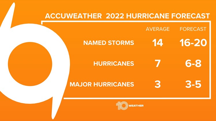
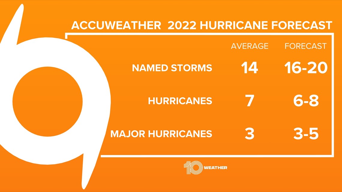
In an average year, the Atlantic basin produces 14 tropical storms, 7 of those turn into hurricanes and 3 of those hurricanes turn into major hurricanes. AccuWeather has predicted 16-20 tropical storms, 6-8 hurricanes and 3-5 major hurricanes.

Why such an active season? AccuWeather highlights two major indicators in their tropical forecast: sea surface temperatures and La Niña – both of which currently favor a more active season.
Let's take a deeper dive to see what the data shows.
Sea Surface Temperatures
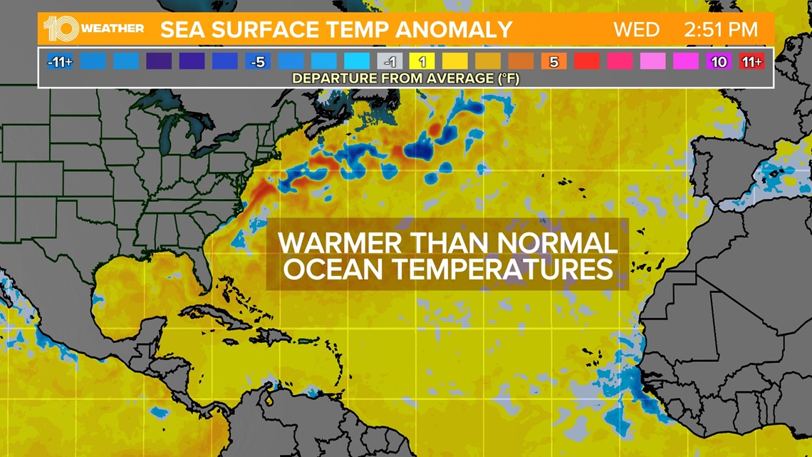
Remember, tropical storms and hurricanes get their energy from warm water temperatures. That's why us meteorologists look at sea surface temperatures. Widespread warmer water temperatures indicate the potential for storms to tap into more energy over a longer period of time.
Current sea surface temperatures are already running above-average this Spring. Notice, in the image below, all the areas in yellow/orange are experiencing warmer tan average water temperatures. The few pockets of blue show areas with below-average sea surface temperatures.
This clearly shows that water temperatures are largely above-average and will likely continue into the Summer months favoring a more active Atlantic tropical season.

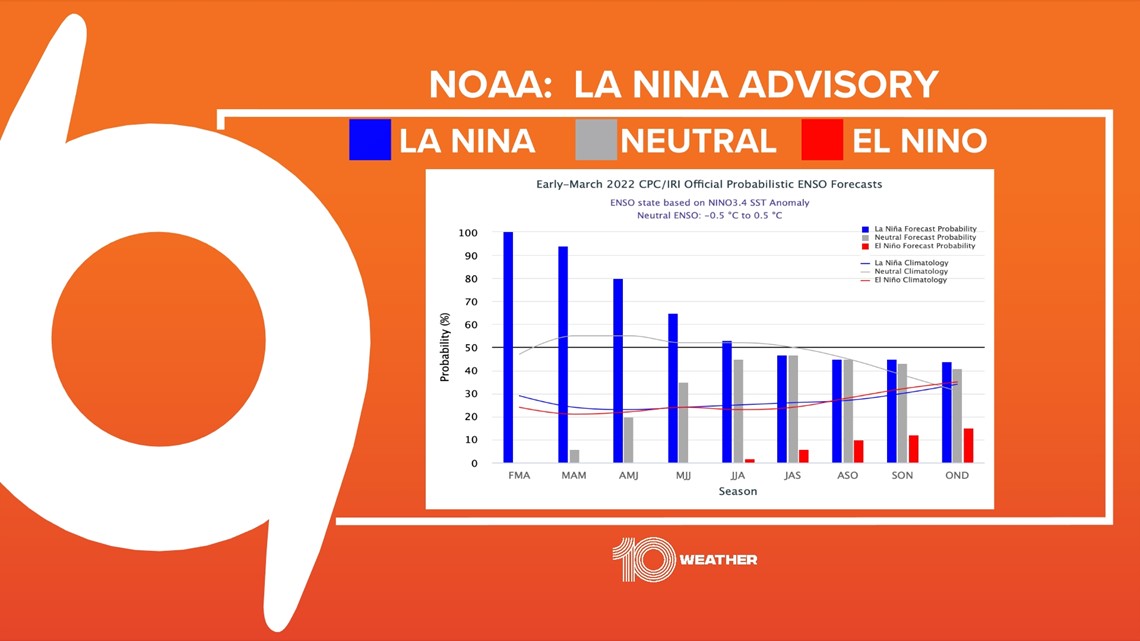
La Niña
Sea surface temperatures are also the driving force for our second tropical indicator. But these water temperatures are much further away off the coast of South America in the eastern Pacific. This is referring to something called the El Niño–Southern Oscillation or ENSO for short. ENSO has three potential phases; La Niña, Neutral and El Niño.
We are currently in a La Niña phase with a La Niña Advisory. That just means that La Niña conditions are expected to continue. A La Niña is when cooler than normal tropical Pacific sea surface temperatures are in place.
In the image below you can see the blue bars indicating that La Niña is expected to continue for the next few months. That will keep it around through hurricane season.

Why is this important?
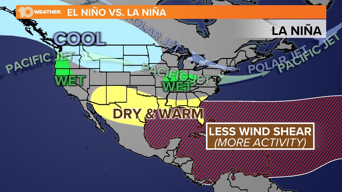
A La Niña phase can lead to certain global weather patterns. Those patterns include hurricane season trends. When a La Niña phase is around for hurricane season, we can expect lighter winds which means less wind shear. When there is less wind shear, tropical storms and hurricanes can develop and strengthen. This is just another reason why this season could be more active than normal.

Overall, early indications do show a more favorable environment this hurricane season. Of course, it only takes one landfalling storm to make a hurricane season memorable. Stay with 10 Tampa Bay, your Hurricane Headquarters, for the latest as hurricane season approaches.