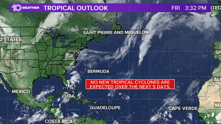
It's been a record-breaking 2020 hurricane season in the Atlantic basin. However, it's suddenly become very quiet with no storms being tracked and no storms expected to develop over the next five days. Nap mode, if you will.
You can likely thank the Madden–Julian Oscillation (MJO) and a Kelvin Wave. This happened in early August as well, when I wrote that the first few weeks of August, the MJO has the tropics looking quiet.
Now, it's happening again. What’s it all mean? Several times a year, the MJO is a strong contributor to various extreme events in the United States, including Arctic outbreaks during winter. MJO can also play a significant part in tropical development.
The MJO is an eastward-moving area of increased uplift (resulting in more rainfall and winds) that circles the globe in the tropics. In general, it takes this disturbance 30-60 days to circle the Earth and return to its starting point. Well, it's back around after its visit in August.
There are two phases associated with the MJO. A convective (enhanced rainfall) phase, and a suppressed rainfall phase. These phases normally cover roughly half the globe, so the result is roughly half the planet sees enhanced rain and storms and half the planet sees suppressed rain and storms.
As you can see in the graphic above, the Atlantic basin has suddenly moved into a suppressed phase. This should last into early October when a convective phase returns.
Another atmospheric influence is the Kelvin Wave. Atmospheric Kelvin waves are tropical rainfall systems accompanied by distinctive westerly and easterly wind patterns. Convectively-suppressed Kelvin Waves, which we are seeing now, help suppress tropical development. Convectively-active Kelvin Waves make tropical cyclone development more likely. They move through the tropics in a similar pattern as the MJO.

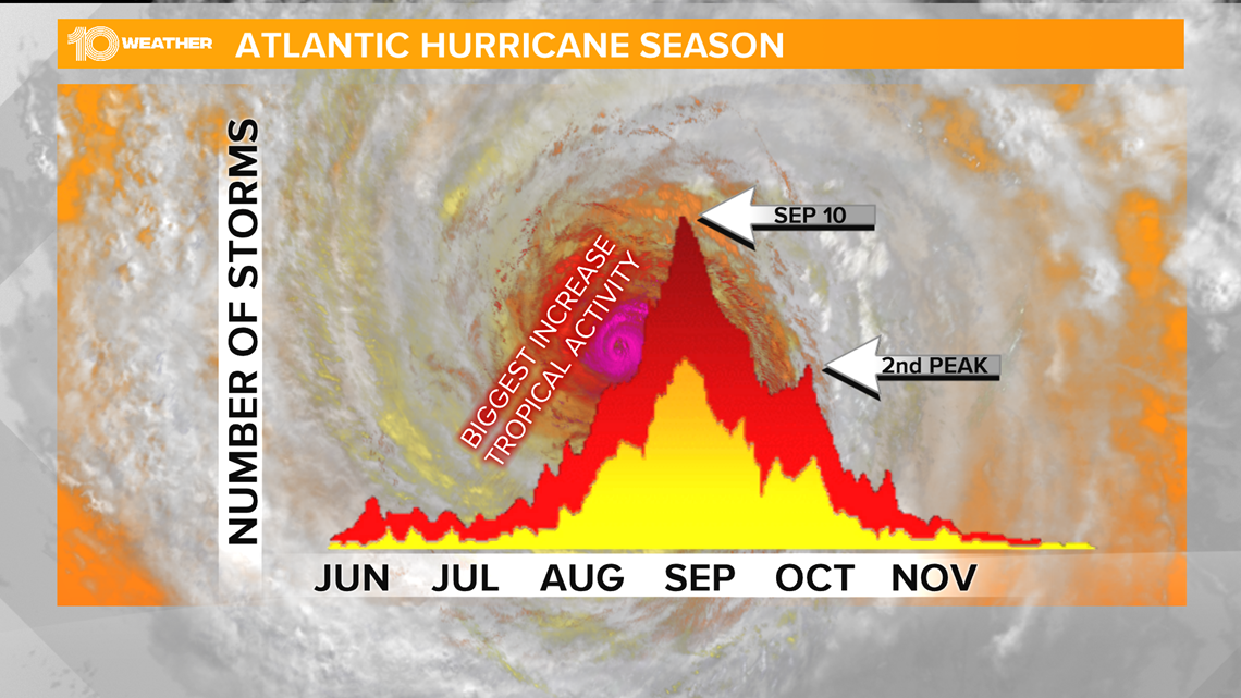
The MJO and the Kelvin Wave is likely to become more favorable as we move into October, just in time for the typical second peak of the Atlantic basin hurricane season.
The science surrounding the MJO and Kelvin Waves continues to evolve, and as we continue to learn more about the MJO and its influences, better long-term hurricane forecasts should result.
What other people are reading right now:
- DeSantis wants to ease restaurant restrictions, may override local rules
- $5K reward offered for information in deadly shooting of Florida 3-year-old
- NCAA recommends waving requirements, making all college football teams eligible for bowls in 2020
- FHP: Man installing I-4 roadway marker killed after being hit by car, thrown from overpass
- Retired circus elephants get new home at northeastern Florida refuge
- Rare, 'patternless' rattlesnake found in Florida
- Results of climate change: Warmer world, stronger storms
►Breaking news and weather alerts: Get the free 10 Tampa Bay app
►Stay In the Know! Sign up now for the Brightside Blend Newsletter