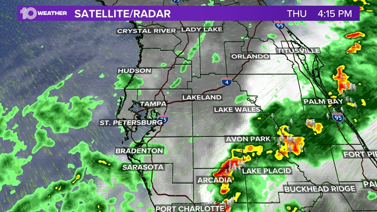
TAMPA, Fla. — A tornado watch was allowed to expire at 4 p.m. for all of the Tampa Bay area. Earlier in the day there was the threat of tornadoes and waterspouts, but that risk has started to decrease.
The National Weather Service has been out surveying some damage in parts of the Tampa area, including Pinellas County where a possible tornado touched down.
Latest updates
4:04 p.m.: The tornado watch has been dropped for all counties.
1:30 p.m.: An investigation is underway into damage caused by a possible tornado Thursday afternoon in the city's Disston Heights neighborhood.
12:54 p.m.: (CANCELED) A severe thunderstorm warning is in effect until 1:30 p.m. for northeastern Manatee and southeastern Hillsborough counties. Damaging winds up to 60 mph.
12:09 p.m.: (CANCELED) A severe thunderstorm warning is in effect until 12:30 p.m. for southeastern Pinellas and central Hillsborough counties. Damaging winds up to 60 mph are possible.
10:56 a.m.: (CANCELED) A tornado warning is in effect until 11:30 a.m. for northeastern Pasco and southeastern Hernando counties. Radar indicated rotation is moving northeast at 35 mph.
10:40 a.m.: (CANCELED) A severe thunderstorm warning is in effect until 11:30 a.m. for parts of Hernando, Pasco, Pinellas and Hillsborough counties for damaging winds up to 60 mph and penny-size hail.
10:08 a.m.: (CANCELED) A severe thunderstorm warning is in effect until 10:45 a.m. for parts of Hernando and Pasco counties for the threat of damaging winds and small hail.
Damage to roofs, siding and trees are possible, according to the National Weather Service.
While there may be just enough lift to support some strong to severe storms as an approaching storm system moves through the Florida west coast, the overall threat will actually diminish from north to south throughout the day Thursday.
The best chance of rain and even some strong storms are most likely Thursday morning in counties north of Tampa Bay. This threat drifts south of Tampa Bay in the afternoon as the severe weather threat decreases.
Once the front pushes through the area, cooler air will start to filter in behind it, bringing down our temperatures. Dew points will also drop considerably once the front has passed — meaning you will really feel that drier air take over the region.