ST. PETERSBURG, Fla. — Hurricane Idalia officially made landfall Wednesday morning along Florida's Big Bend near Keaton Beach.
Idalia is packing winds of 125 mph near the Florida Panhandle and into the Big Bend region.
Outer rainbands continue to push their way into the Tampa Bay region. Life-threatening storm surge, hurricane-force wind and isolated tornadoes are likely for portions of the Florida Gulf Coast.
It's important to stress small shifts in Idalia's track will continue before the storm makes landfall — and parts of the region will still experience the "dirty" side of the system.
A hurricane warning is in effect from the middle of Longboat Key northward to Indian Pass, including Tampa Bay. A storm surge warning is in effect for Englewood northward to Indian Pass, including Tampa Bay.
Hurricane Idalia has maximum sustained winds of 125 mph and is located about 20 miles west-southwest of Perry, according to the National Hurricane Center's latest advisory. Its movement is north at 18 mph.
Idalia is a "dangerous" major hurricane — Category 3 or higher — over the northeastern Gulf of Mexico. The NHC says heavy rainfall is likely to impact a portion of the west coast of the state, the Panhandle and southeast region.
Both the European weather model and GFS model, or what we call the American model, drifts the storm into the Gulf of Mexico then right along the Tampa Bay area coast through Wednesday.
Hurricane-force wind is possible into Wednesday, with a 4-11 foot storm surge from Tampa Bay northward. Heavy rainfall is likely, and there is the chance of tornadoes.
10 Tampa Bay is keeping you ahead of the storm: Download our free mobile app for real-time storm information and breaking alerts, and download 10 Tampa Bay+ for your favorite streaming device for live updates.
See below for the latest breakdown of threats from Idalia.
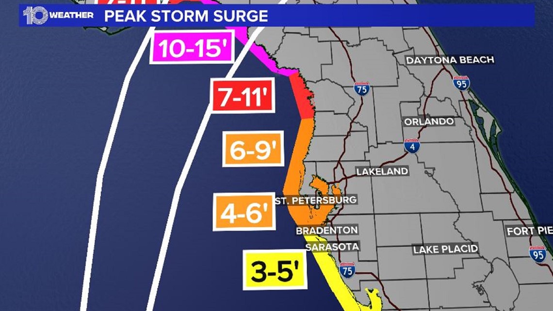
Hurricane Idalia storm surge threat
There is the potential of a 6-11 foot storm surge in Levy/Citrus counties — and it could be at least 6 feet higher than what Hermine brought in 2016. Expect a 6-9 foot surge in Hernando/Pasco counties and a 4-6 foot surge in the Tampa Bay area.
South of Longboat Key, the forecast is for a 3-5 foot storm surge.

Wind risk
Hurricane-force wind is likely along the coastline, with the highest chances in Citrus, Hernando, Hillsborough, Pasco, Pinellas, Manatee and Sarasota counties. The earliest arrival time of at least tropical storm force wind is Tuesday morning.
Flooding potential
The main flooding threat is Tuesday night into Wednesday, especially along the coast where a slight risk exists for scattered flash flooding. The chance of rain flooding streets near the coast increases especially at high tide.
At least 6 inches of rain is possible along the coast, with lesser amounts inland.
Tornado risk
The main threat of tornadoes exists on Tuesday and Tuesday night with the arrival of the storm's rotating rain bands.
Make sure those hurricane kits are ready to go and that you have your plan updated. A disaster-preparedness sales tax holiday is ongoing, meaning you could save on important hurricane kit items, including high-priced items such as generators.